
Kelurahan Simpang Baru topographic map
Interactive map
Click on the map to display elevation.
About this map
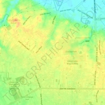
Name: Kelurahan Simpang Baru topographic map, elevation, terrain.
Location: Kelurahan Simpang Baru, Kabupaten Kampar, Riau, Indonesien (0.46029 101.34949 0.50278 101.39995)
Average elevation: 27 m
Minimum elevation: 7 m
Maximum elevation: 41 m
Other topographic maps
Click on a map to view its topography, its elevation and its terrain.
Pekanbaru
Indonesien > Riau > Kabupaten Kampar
Pekanbaru, Kabupaten Kampar, Riau, 28141, Indonesien
Average elevation: 22 m