
Gutach topographic map
Interactive map
Click on the map to display elevation.
About this map
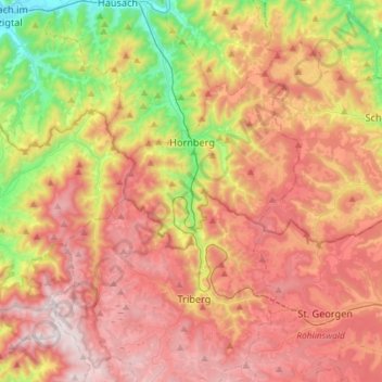
Name: Gutach topographic map, elevation, terrain.
Average elevation: 724 m
Minimum elevation: 213 m
Maximum elevation: 1,171 m
Other topographic maps
Click on a map to view its topography, its elevation and its terrain.
Mattenhof
Deutschland > Baden-Württemberg > Ortenaukreis > Gutach (Schwarzwaldbahn)
Mattenhof, Gutach (Schwarzwaldbahn), Verwaltungsgemeinschaft Hausach, Ortenaukreis, Baden-Württemberg, 77793, Deutschland
Average elevation: 402 m
Vogtsbauernhof
Deutschland > Baden-Württemberg > Ortenaukreis > Gutach (Schwarzwaldbahn)
Vogtsbauernhof, Wählerhöfe, Gutach (Schwarzwaldbahn), Verwaltungsgemeinschaft Hausach, Ortenaukreis, Baden-Württemberg, 77793, Deutschland
Average elevation: 378 m