
Paros topographic map
Interactive map
Click on the map to display elevation.
About this map
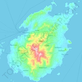
Name: Paros topographic map, elevation, terrain.
Average elevation: 69 m
Minimum elevation: -1 m
Maximum elevation: 735 m
Other topographic maps
Click on a map to view its topography, its elevation and its terrain.
Parikia
Griechenland > Ägäis > Regionalbezirk Paros
Parikia, Δήμος Πάρου, Regionalbezirk Paros, Region Südliche Ägäis, Ägäis, 844 00, Griechenland
Average elevation: 116 m
Καλάμι
Griechenland > Ägäis > Regionalbezirk Paros
Καλάμι, Δήμος Πάρου, Regionalbezirk Paros, Region Südliche Ägäis, Ägäis, 844 00, Griechenland
Average elevation: 59 m