
Gramzow topographic map
Interactive map
Click on the map to display elevation.
About this map
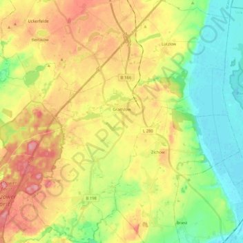
Name: Gramzow topographic map, elevation, terrain.
Location: Gramzow, Uckermark, Brandenburg, Deutschland (53.14296 13.92140 53.26494 14.09807)
Average elevation: 56 m
Minimum elevation: 7 m
Maximum elevation: 116 m
Zu Gramzow gehören die Ortsteile Gramzow, Lützlow, Meichow und Polßen sowie die Wohnplätze Ausbau, Forsthaus, Karlshof, Koboltenhof, Neumeichow, Randowhöhe und Zehnebeck.[2]