
Wahnsdorf topographic map
Interactive map
Click on the map to display elevation.
About this map
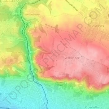
Name: Wahnsdorf topographic map, elevation, terrain.
Location: Wahnsdorf, Radebeul, Meißen, Sachsen, Deutschland (51.11095 13.65326 51.12837 13.69310)
Average elevation: 190 m
Minimum elevation: 113 m
Maximum elevation: 249 m
Other topographic maps
Click on a map to view its topography, its elevation and its terrain.
Lindenau
Deutschland > Sachsen > Meißen > Radebeul
Lindenau, Radebeul, Meißen, Sachsen, Deutschland
Average elevation: 177 m
Alt-Radebeul
Deutschland > Sachsen > Meißen > Radebeul
Alt-Radebeul, Radebeul, Meißen, Sachsen, Deutschland
Average elevation: 121 m