
Thank you for supporting this site ❤️
Make a donation
Make a donation
Mauguio topographic map
Click on the map to display elevation.
Thank you for supporting this site ❤️
Make a donation
Make a donation
Mauguio
The altitude of the village is between 4 and 6 meters above sea level, the mont is a raised net peaking at more than 20 meters. This anomaly cannot receive any explanation from a geological point of view, because it is indeed a totally artificial relief created by the lords of the region, the Lords of Melgueil, to establish their castle.
Thank you for supporting this site ❤️
Make a donation
Make a donation
About this map
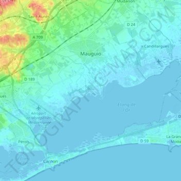
Name: Mauguio topographic map, elevation, terrain.
Average elevation: 7 m
Minimum elevation: -3 m
Maximum elevation: 71 m
Thank you for supporting this site ❤️
Make a donation
Make a donation
Other topographic maps
Click on a map to view its topography, its elevation and its terrain.