
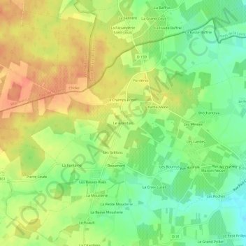
Le Brandais topographic map
Interactive map
Click on the map to display elevation.
About this map
Name: Le Brandais topographic map, elevation, terrain.
Average elevation: 67 m
Minimum elevation: 43 m
Maximum elevation: 88 m
Other topographic maps
Click on a map to view its topography, its elevation and its terrain.
79290
France > Nouvelle-Aquitaine > Deux-Sèvres > Loretz-d'Argenton > Le Petit Ursay
79290, Le Petit Ursay, Bouillé-Loretz, Loretz-d'Argenton, Bressuire, Deux-Sèvres, Nouvelle-Aquitaine, France métropolitaine, France
Average elevation: 55 m
Jarles
France > Nouvelle-Aquitaine > Deux-Sèvres > Loretz-d'Argenton
Jarles, Bouillé-Loretz, Loretz-d'Argenton, Bressuire, Deux-Sèvres, Nouvelle-Aquitaine, France métropolitaine, 79290, France
Average elevation: 50 m
Loretz-d'Argenton
France > Nouvelle-Aquitaine > Deux-Sèvres > Loretz-d'Argenton
Loretz-d'Argenton, Bressuire, Deux-Sèvres, Nouvelle-Aquitaine, France métropolitaine, 79290, France
Average elevation: 57 m
Argenton-l'Église
France > Nouvelle-Aquitaine > Deux-Sèvres > Loretz-d'Argenton
Argenton-l'Église, Loretz-d'Argenton, Bressuire, Deux-Sèvres, Nouvelle-Aquitaine, France métropolitaine, 79290, France
Average elevation: 58 m