
Ала-Бука topographic map
Interactive map
Click on the map to display elevation.
About this map
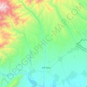
Name: Ала-Бука topographic map, elevation, terrain.
Location: Ала-Бука, Gebiet Dschalalabat, Kirgisistan (41.35029 71.37553 41.60391 71.48186)
Average elevation: 1,684 m
Minimum elevation: 1,067 m
Maximum elevation: 3,920 m
Other topographic maps
Click on a map to view its topography, its elevation and its terrain.
Dschalalabat
Kirgisistan > Gebiet Dschalalabat > Dschalalabat
Dschalalabat, Gebiet Dschalalabat, 715600, Kirgisistan
Average elevation: 928 m