
Fresne-Cauverville topographic map
Interactive map
Click on the map to display elevation.
About this map
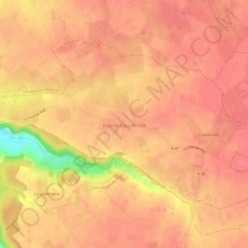
Name: Fresne-Cauverville topographic map, elevation, terrain.
Average elevation: 161 m
Minimum elevation: 111 m
Maximum elevation: 173 m
Other topographic maps
Click on a map to view its topography, its elevation and its terrain.
Fresne
France > Normandie > Eure > Fresne-Cauverville
Fresne, Fresne-Cauverville, Bernay, Eure, Normandie, France métropolitaine, 27260, France
Average elevation: 161 m