
Saint-Paul-de-Loubressac topographic map
Interactive map
Click on the map to display elevation.
About this map
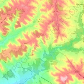
Name: Saint-Paul-de-Loubressac topographic map, elevation, terrain.
Average elevation: 222 m
Minimum elevation: 133 m
Maximum elevation: 308 m
Other topographic maps
Click on a map to view its topography, its elevation and its terrain.
Flaugnac
France > Occitanie > Lot > Saint-Paul-Flaugnac
Flaugnac, Saint-Paul-Flaugnac, Cahors, Lot, Occitanie, France métropolitaine, 46170, France
Average elevation: 225 m
Les Justices
France > Occitanie > Lot > Saint-Paul-Flaugnac
Les Justices, Saint-Paul-de-Loubressac, Saint-Paul-Flaugnac, Cahors, Lot, Occitanie, France métropolitaine, 46170, France
Average elevation: 243 m