
Scharans topographic map
Interactive map
Click on the map to display elevation.
About this map
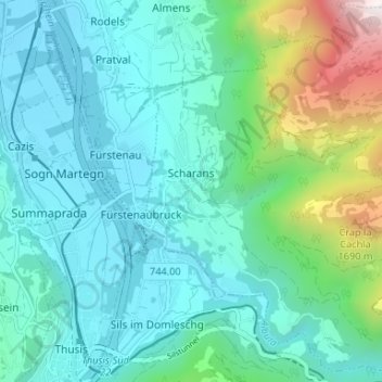
Name: Scharans topographic map, elevation, terrain.
Location: Scharans, Viamala, Graubünden, 7412, Schweiz (46.69345 9.45145 46.73853 9.51321)
Average elevation: 937 m
Minimum elevation: 635 m
Maximum elevation: 2,206 m
Other topographic maps
Click on a map to view its topography, its elevation and its terrain.
Splügen
Schweiz > Graubünden > Viamala > Rheinwald
Splügen, Rheinwald, Viamala, Graubünden, Schweiz
Average elevation: 2,151 m
Thusis
Schweiz > Graubünden > Viamala > Thusis
Thusis, Viamala, Graubünden, 7430, Schweiz
Average elevation: 927 m