
Priddy topographic map
Interactive map
Click on the map to display elevation.
About this map
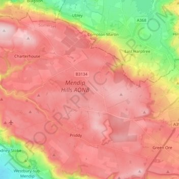
Name: Priddy topographic map, elevation, terrain.
Average elevation: 206 m
Minimum elevation: 7 m
Maximum elevation: 325 m
Other topographic maps
Click on a map to view its topography, its elevation and its terrain.
Mendip
Royaume-Uni > Angleterre > Mendip
Mendip, Somerset, South West England, Angleterre, Royaume-Uni
Average elevation: 98 m