
Thank you for supporting this site ❤️
Make a donation
Make a donation
North Las Vegas topographic map
Click on the map to display elevation.
Thank you for supporting this site ❤️
Make a donation
Make a donation
About this map
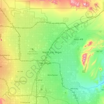
Name: North Las Vegas topographic map, elevation, terrain.
Average elevation: 677 m
Minimum elevation: 430 m
Maximum elevation: 1,233 m
Thank you for supporting this site ❤️
Make a donation
Make a donation
Other topographic maps
Click on a map to view its topography, its elevation and its terrain.
Carey–Lake Mead Detention Basin
United States > Nevada > Clark County > North Las Vegas
Average elevation: 648 m