
吉林市 topographic map
Interactive map
Click on the map to display elevation.
About this map
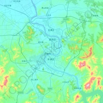
Name: 吉林市 topographic map, elevation, terrain.
Location: 吉林市, 文庙街道, 昌邑区, 吉林市, 吉林省, 132011, 中国 (43.68177 126.40051 44.00177 126.72051)
Average elevation: 264 m
Minimum elevation: 174 m
Maximum elevation: 844 m
城区为河谷盆地地形,平均海拔约200米,四面被龙潭山、小白山、朱雀山、玄天岭环抱,如神话中青龙、白虎、朱雀、玄武四神拱卫,又有松花江穿城而过。近年来吉林市向西北北穿过玄天岭发展,而东南面则由于山岭阻隔,发展缓慢。近年来,吉林市南部沿松花江河湾区域发展较快,如丰满区松江南路地区。