
Gipuzkoa topographic map
Interactive map
Click on the map to display elevation.
About this map
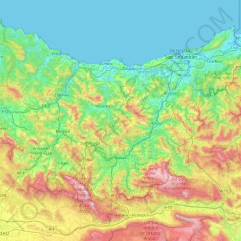
Name: Gipuzkoa topographic map, elevation, terrain.
Location: Gipuzkoa, Autonomous Community of the Basque Country, Spain (42.89507 -2.60271 43.39596 -1.72927)
Average elevation: 396 m
Minimum elevation: -3 m
Maximum elevation: 1,497 m
Other topographic maps
Click on a map to view its topography, its elevation and its terrain.
Arratzu
Spain > Autonomous Community of the Basque Country
Arratzu, Biscay, Autonomous Community of the Basque Country, 48383, Spain
Average elevation: 114 m
Zizurkil
Spain > Autonomous Community of the Basque Country
Zizurkil, Gipuzkoa, Autonomous Community of the Basque Country, 20159, Spain
Average elevation: 217 m
Soil
Spain > Autonomous Community of the Basque Country > Montaña Alavesa/Arabako Mendialdea
Soil, Arraia-Maeztu, Montaña Alavesa/Arabako Mendialdea, Álava, Autonomous Community of the Basque Country, 01207, Spain
Average elevation: 898 m
Altzo
Spain > Autonomous Community of the Basque Country
Altzo, Gipuzkoa, Autonomous Community of the Basque Country, 20268, Spain
Average elevation: 274 m
Peñacerrada-Urizaharra
Spain > Autonomous Community of the Basque Country > Montaña Alavesa/Arabako Mendialdea
Peñacerrada-Urizaharra, Montaña Alavesa/Arabako Mendialdea, Álava, Autonomous Community of the Basque Country, Spain
Average elevation: 767 m
Labastida/Bastida
Spain > Autonomous Community of the Basque Country > Arabako Errioxa/Rioja Alavesa
Labastida/Bastida, Arabako Errioxa/Rioja Alavesa, Álava, Autonomous Community of the Basque Country, 01330, Spain
Average elevation: 611 m
Salinillas de Buradón/Gatzaga Buradon
Spain > Autonomous Community of the Basque Country > Arabako Errioxa/Rioja Alavesa > Labastida/Bastida
Salinillas de Buradón/Gatzaga Buradon, Labastida/Bastida, Arabako Errioxa/Rioja Alavesa, Álava, Autonomous Community of the Basque Country, Spain
Average elevation: 599 m
Vitoria-Gasteiz
Spain > Autonomous Community of the Basque Country > Gasteizko kuadrilla/Cuadrilla de Vitoria
Vitoria-Gasteiz, Gasteizko kuadrilla/Cuadrilla de Vitoria, Álava, Autonomous Community of the Basque Country, Spain
Average elevation: 626 m
Oiartzun
Spain > Autonomous Community of the Basque Country > Donostialdea
Oiartzun, Donostialdea, Gipuzkoa, Autonomous Community of the Basque Country, 20180, Spain
Average elevation: 251 m
Álava
Spain > Autonomous Community of the Basque Country
Álava, Autonomous Community of the Basque Country, 01008, Spain
Average elevation: 526 m
Meñaka
Spain > Autonomous Community of the Basque Country > Andraka
Meñaka, Andraka, Biscay, Autonomous Community of the Basque Country, 48620, Spain
Average elevation: 184 m
Álava
Spain > Autonomous Community of the Basque Country
Álava, Autonomous Community of the Basque Country, 01007, Spain
Average elevation: 561 m
Pasaia
Spain > Autonomous Community of the Basque Country > Donostialdea
Pasaia, Donostialdea, Gipuzkoa, Autonomous Community of the Basque Country, 20110, Spain
Average elevation: 40 m
Bedaroa
Spain > Autonomous Community of the Basque Country > Ea
Bedaroa, Ea, Biscay, Autonomous Community of the Basque Country, 48287, Spain
Average elevation: 74 m
Hondarribia/Fontarrabie
Spain > Autonomous Community of the Basque Country > Bidasoa Beherea / Bajo Bidasoa
Hondarribia/Fontarrabie, Bidasoa Beherea / Bajo Bidasoa, Gipuzkoa, Autonomous Community of the Basque Country, 20280, Spain
Average elevation: 37 m
Donostia / San Sebastián
Spain > Autonomous Community of the Basque Country > Donostialdea > Donostia / San Sebastián
Donostia / San Sebastián, San Sebastián, Donostialdea, Gipuzkoa, Autonomous Community of the Basque Country, 20003, Spain
Average elevation: 134 m
Arratia-Nerbioi
Spain > Autonomous Community of the Basque Country
Arratia-Nerbioi, Biscay, Autonomous Community of the Basque Country, Spain
Average elevation: 451 m
Sopelana
Spain > Autonomous Community of the Basque Country > Sopelana
Sopelana, Biscay, Autonomous Community of the Basque Country, Spain
Average elevation: 63 m
Armentia
Spain > Autonomous Community of the Basque Country > Gasteizko kuadrilla/Cuadrilla de Vitoria > Vitoria-Gasteiz
Armentia, Vitoria-Gasteiz, Gasteizko kuadrilla/Cuadrilla de Vitoria, Álava, Autonomous Community of the Basque Country, Spain
Average elevation: 664 m
Zikuñaga
Spain > Autonomous Community of the Basque Country > Donostialdea > Hernani > Zikuñaga
Zikuñaga, Hernani, Donostialdea, Gipuzkoa, Autonomous Community of the Basque Country, 20120, Spain
Average elevation: 62 m
Laguardia
Spain > Autonomous Community of the Basque Country > Arabako Errioxa/Rioja Alavesa
Laguardia, Arabako Errioxa/Rioja Alavesa, Álava, Autonomous Community of the Basque Country, Spain
Average elevation: 592 m
Hondarribia
Spain > Autonomous Community of the Basque Country > Bidasoa Beherea / Bajo Bidasoa > Hondarribia
Hondarribia, Bidasoa Beherea / Bajo Bidasoa, Gipuzkoa, Autonomous Community of the Basque Country, Spain
Average elevation: 34 m
Araotz
Spain > Autonomous Community of the Basque Country > Debagoiena > Oñati > Araotz
Araotz, Oñati, Debagoiena, Gipuzkoa, Autonomous Community of the Basque Country, 20568, Spain
Average elevation: 625 m
Legazpi
Spain > Autonomous Community of the Basque Country
Legazpi, Gipuzkoa, Autonomous Community of the Basque Country, Spain
Average elevation: 548 m
Mendaro
Spain > Autonomous Community of the Basque Country > Debabarrena > Mendaro
Mendaro, Debabarrena, Gipuzkoa, Autonomous Community of the Basque Country, 20850, Spain
Average elevation: 290 m
Usurbil
Spain > Autonomous Community of the Basque Country > Donostialdea
Usurbil, Donostialdea, Gipuzkoa, Autonomous Community of the Basque Country, 20170, Spain
Average elevation: 138 m
Ibarra
Spain > Autonomous Community of the Basque Country > Tolosaldea
Ibarra, Tolosaldea, Gipuzkoa, Autonomous Community of the Basque Country, 20400, Spain
Average elevation: 259 m
Irun
Spain > Autonomous Community of the Basque Country > Bidasoa Beherea / Bajo Bidasoa
Irun, Bidasoa Beherea / Bajo Bidasoa, Gipuzkoa, Autonomous Community of the Basque Country, Spain
Average elevation: 163 m
Barakaldo
Spain > Autonomous Community of the Basque Country > Barakaldo
Barakaldo, Biscay, Autonomous Community of the Basque Country, Spain
Average elevation: 127 m
Oyón/Oion
Spain > Autonomous Community of the Basque Country > Arabako Errioxa/Rioja Alavesa
Oyón/Oion, Arabako Errioxa/Rioja Alavesa, Álava, Autonomous Community of the Basque Country, 01320, Spain
Average elevation: 572 m
Eskibel
Spain > Autonomous Community of the Basque Country > Vitoria-Gasteiz
Eskibel, Vitoria-Gasteiz, Gasteizko kuadrilla/Cuadrilla de Vitoria, Álava, Autonomous Community of the Basque Country, Spain
Average elevation: 680 m
Orio
Spain > Autonomous Community of the Basque Country > Orio
Orio, Urola-Kosta, Gipuzkoa, Autonomous Community of the Basque Country, 20810, Spain
Average elevation: 50 m
Bilbao
Spain > Autonomous Community of the Basque Country
Bilbao, Biscay, Autonomous Community of the Basque Country, Spain
Average elevation: 156 m
Gautegiz Arteaga
Spain > Autonomous Community of the Basque Country > Gautegiz Arteaga
Gautegiz Arteaga, Biscay, Autonomous Community of the Basque Country, Spain
Average elevation: 137 m
Errenteria
Spain > Autonomous Community of the Basque Country > Donostialdea
Errenteria, Donostialdea, Gipuzkoa, Autonomous Community of the Basque Country, 20100, Spain
Average elevation: 190 m
Biscay
Spain > Autonomous Community of the Basque Country
Biscay, Autonomous Community of the Basque Country, Spain
Average elevation: 333 m
Elgoibar
Spain > Autonomous Community of the Basque Country > Debabarrena
Elgoibar, Debabarrena, Gipuzkoa, Autonomous Community of the Basque Country, Spain
Average elevation: 321 m
Beasain
Spain > Autonomous Community of the Basque Country
Beasain, Gipuzkoa, Autonomous Community of the Basque Country, Spain
Average elevation: 383 m
Álava
Spain > Autonomous Community of the Basque Country
Álava, Autonomous Community of the Basque Country, Spain
Average elevation: 597 m