
Thank you for supporting this site ❤️
Make a donation
Make a donation
Acton topographic map
Click on the map to display elevation.
Thank you for supporting this site ❤️
Make a donation
Make a donation
About this map
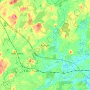
Name: Acton topographic map, elevation, terrain.
Location: Acton, Middlesex County, Massachusetts, United States (42.43694 -71.49855 42.53403 -71.38495)
Average elevation: 66 m
Minimum elevation: 31 m
Maximum elevation: 135 m
Thank you for supporting this site ❤️
Make a donation
Make a donation
Other topographic maps
Click on a map to view its topography, its elevation and its terrain.
Arlington Heights
United States > Massachusetts > Middlesex County > Arlington
Average elevation: 58 m