
Thank you for supporting this site ❤️
Make a donation
Make a donation
Castelo Branco topographic map
Click on the map to display elevation.
Thank you for supporting this site ❤️
Make a donation
Make a donation
About this map
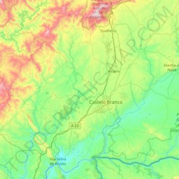
Name: Castelo Branco topographic map, elevation, terrain.
Location: Castelo Branco, Portugal (39.64085 -7.85076 40.08365 -7.17915)
Average elevation: 365 m
Minimum elevation: 71 m
Maximum elevation: 1,209 m
Thank you for supporting this site ❤️
Make a donation
Make a donation
Other topographic maps
Click on a map to view its topography, its elevation and its terrain.