
Make a donation
Neuschwanstein Castle topographic map
Click on the map to display elevation.
Make a donation
Neuschwanstein Castle
The municipality of Schwangau lies at an elevation of 800 m (2,620 ft) at the southwest border of the German state of Bavaria. Its surroundings are characterised by the transition between the Alpine foothills in the south (toward the nearby Austrian border) and a hilly landscape in the north that appears flat by comparison. In the Middle Ages, three castles overlooked the villages. One was called Schwanstein Castle. In 1832, Ludwig's father, King Maximilian II of Bavaria, bought its ruins to replace them with the comfortable neo-Gothic palace known as Hohenschwangau Castle. Finished in 1837, the palace became his family's summer residence, and his elder son Ludwig (born 1845) spent a large part of his childhood here.
Make a donation
About this map
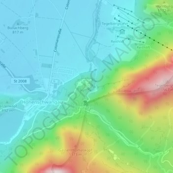
Name: Neuschwanstein Castle topographic map, elevation, terrain.
Average elevation: 982 m
Minimum elevation: 788 m
Maximum elevation: 1,541 m
Make a donation
Other topographic maps
Click on a map to view its topography, its elevation and its terrain.