
Thank you for supporting this site ❤️
Make a donation
Make a donation
Marthasville topographic map
Click on the map to display elevation.
Thank you for supporting this site ❤️
Make a donation
Make a donation
About this map
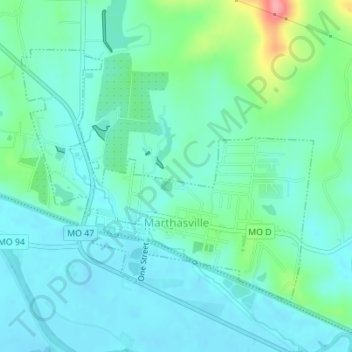
Name: Marthasville topographic map, elevation, terrain.
Location: Marthasville, Warren County, Missouri, United States (38.62231 -91.07250 38.64170 -91.04379)
Average elevation: 166 m
Minimum elevation: 144 m
Maximum elevation: 245 m
Thank you for supporting this site ❤️
Make a donation
Make a donation
Other topographic maps
Click on a map to view its topography, its elevation and its terrain.
Little Lost Creek Conservation Area
United States > Missouri > Warren County > Pendleton
Average elevation: 241 m