
Saint-Aubin-Château-Neuf topographic map
Interactive map
Click on the map to display elevation.
About this map
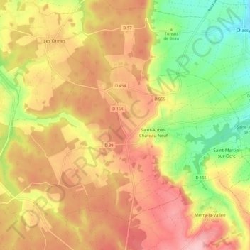
Name: Saint-Aubin-Château-Neuf topographic map, elevation, terrain.
Average elevation: 211 m
Minimum elevation: 119 m
Maximum elevation: 287 m
Saint-Aubin-Château-Neuf est situé dans l'Yonne, avec Auxerre à 22 kilomètres à l'est et Toucy à 10 km au sud. Paris est à 155 km. La commune appartient au canton d'Aillant-sur-Tholon et à l'arrondissement d'Auxerre. Sa superficie est de 25 km2 et son altitude moyenne de environ 200 mètres.
Other topographic maps
Click on a map to view its topography, its elevation and its terrain.
D 955
France > Bourgogne-Franche-Comté > Yonne > Le Val d'Ocre
D 955, Beaurain, Saint-Aubin-Château-Neuf, Le Val d'Ocre, Auxerre, Yonne, Bourgogne-Franche-Comté, France métropolitaine, 89110, France
Average elevation: 236 m
Lampy
France > Bourgogne-Franche-Comté > Yonne > Le Val d'Ocre
Lampy, Saint-Aubin-Château-Neuf, Le Val d'Ocre, Auxerre, Yonne, Bourgogne-Franche-Comté, France métropolitaine, 89110, France
Average elevation: 207 m