
Lissberg topographic map
Interactive map
Click on the map to display elevation.
About this map
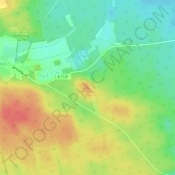
Name: Lissberg topographic map, elevation, terrain.
Average elevation: 134 m
Minimum elevation: 108 m
Maximum elevation: 162 m
Other topographic maps
Click on a map to view its topography, its elevation and its terrain.
Jocksdorf
Deutschland > Brandenburg > Spree-Neiße > Neiße-Malxetal
Jocksdorf, Neiße-Malxetal, Döbern-Land, Spree-Neiße, Brandenburg, Deutschland
Average elevation: 99 m
Preschen
Deutschland > Brandenburg > Spree-Neiße > Neiße-Malxetal
Preschen, Neiße-Malxetal, Döbern-Land, Spree-Neiße, Brandenburg, Deutschland
Average elevation: 121 m
Zelz
Deutschland > Brandenburg > Spree-Neiße > Neiße-Malxetal
Zelz, Neiße-Malxetal, Döbern-Land, Spree-Neiße, Brandenburg, Deutschland
Average elevation: 115 m