
Thank you for supporting this site ❤️
Make a donation
Make a donation
Scuol topographic map
Click on the map to display elevation.
Thank you for supporting this site ❤️
Make a donation
Make a donation
Scuol
The God da Tamangur ("the forest back there") is the highest continuous stone pine (pinus cembra) forest in Europe, right at the furthest end of the Val S-charl, south of Scuol. The forest nature reserve covers an area of about 84 ha (210 acres) at up to 2,400 m (7,900 ft) in elevation. Due to the altitude and weather, the trees grow very slowly and may live up to 700 years.
Thank you for supporting this site ❤️
Make a donation
Make a donation
About this map
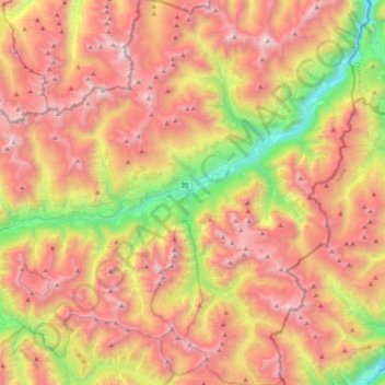
Name: Scuol topographic map, elevation, terrain.
Average elevation: 2,240 m
Minimum elevation: 1,020 m
Maximum elevation: 3,350 m
Thank you for supporting this site ❤️
Make a donation
Make a donation
Other topographic maps
Click on a map to view its topography, its elevation and its terrain.
Ramosch
Switzerland > Grisons > Region Engiadina Bassa/Val Müstair > Valsot
Average elevation: 1,501 m