
Thank you for supporting this site ❤️
Make a donation
Make a donation
Benenberg topographic map
Click on the map to display elevation.
Thank you for supporting this site ❤️
Make a donation
Make a donation
About this map
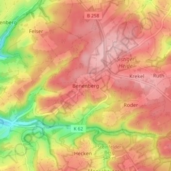
Name: Benenberg topographic map, elevation, terrain.
Average elevation: 549 m
Minimum elevation: 447 m
Maximum elevation: 606 m
Thank you for supporting this site ❤️
Make a donation
Make a donation
Other topographic maps
Click on a map to view its topography, its elevation and its terrain.
Sistiger Heide
Deutschland > Nordrhein-Westfalen > Kreis Euskirchen > Kall > Benenberg
Average elevation: 570 m