
12159 topographic map
Interactive map
Click on the map to display elevation.
About this map
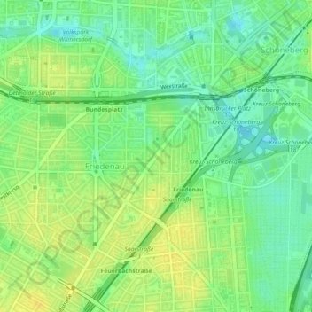
Name: 12159 topographic map, elevation, terrain.
Location: 12159, Friedenau, Tempelhof-Schöneberg, Berlin, Germany (52.47286 13.33687 52.47296 13.33697)
Average elevation: 48 m
Minimum elevation: 36 m
Maximum elevation: 57 m
Other topographic maps
Click on a map to view its topography, its elevation and its terrain.
Friedrichshain-Kreuzberg
Friedrichshain-Kreuzberg, Berlin, Germany
Average elevation: 45 m
Charlottenburg-Wilmersdorf
Charlottenburg-Wilmersdorf, Berlin, Germany
Average elevation: 44 m