
Don Melcho topographic map
Interactive map
Click on the map to display elevation.
About this map
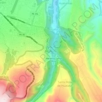
Name: Don Melcho topographic map, elevation, terrain.
Average elevation: 2,802 m
Minimum elevation: 2,589 m
Maximum elevation: 3,097 m
Other topographic maps
Click on a map to view its topography, its elevation and its terrain.
Parque Forestal Canan
Perú > Ayacucho > San Juan Bautista
Parque Forestal Canan, Asoc. Las Américas, San Juan Bautista, Provincia de Huamanga, Ayacucho, Perú
Average elevation: 2,768 m