
Make a donation
Espírito Santo topographic map
Click on the map to display elevation.
Make a donation
Espírito Santo
The Captaincy of Espírito Santo was carved out of the Captaincy of Bahia in the 18th century, during the colonial rule of Brazil, and named after a 16th-century captaincy covering roughly the same area of coast. Following the elevation of Brazil to a constituent kingdom of United Kingdom of Portugal, Brazil and the Algarves in 1815, prompted by the transfer of the Portuguese Court to Brazil, Espírito Santo was elevated to a province. After the independence of Brazil in 1822, it became a province of the newly established Empire of Brazil, and after Brazil became a republic in 1889, it was granted statehood. In the early 20th century, its current state symbols were adopted.
Make a donation
About this map
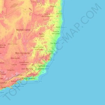
Name: Espírito Santo topographic map, elevation, terrain.
Location: Espírito Santo, Southeast Region, Brazil (-21.43393 -41.87981 -17.89195 -28.62896)
Average elevation: 265 m
Minimum elevation: -1 m
Maximum elevation: 2,500 m
Make a donation
Other topographic maps
Click on a map to view its topography, its elevation and its terrain.
Amazon River
During what many archaeologists called the formative stage, Amazonian societies were deeply involved in the emergence of South America's highland agrarian systems. The trade with Andean civilizations in the terrains of the headwaters in the Andes formed an essential contribution to the social and religious…
Average elevation: 5 m
Amazon River
During what many archaeologists called the formative stage, Amazonian societies were deeply involved in the emergence of South America's highland agrarian systems. The trade with Andean civilizations in the terrains of the headwaters in the Andes formed an essential contribution to the social and religious…
Average elevation: 4 m
Make a donation
Jardim Copacabana
Brazil > São Paulo > Região Metropolitana de São Paulo > São Paulo
Average elevation: 792 m
Rio de Janeiro
Brazil > Rio de Janeiro > Região Metropolitana do Rio de Janeiro > Rio de Janeiro
Temperature also varies according to elevation, distance from the coast, and type of vegetation or land use. During the winter, cold fronts and dawn/morning sea breezes bring mild temperatures; cold fronts, the Intertropical Convergence Zone (in the form of winds from the Amazon Forest), the strongest…
Average elevation: 40 m
Make a donation