
Thank you for supporting this site ❤️
Make a donation
Make a donation
Olivais topographic map
Click on the map to display elevation.
Thank you for supporting this site ❤️
Make a donation
Make a donation
About this map
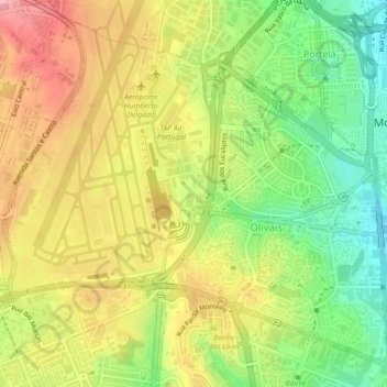
Name: Olivais topographic map, elevation, terrain.
Location: Olivais, Lisbon, Portugal (38.75574 -9.14760 38.78680 -9.10310)
Average elevation: 67 m
Minimum elevation: 4 m
Maximum elevation: 128 m
Thank you for supporting this site ❤️
Make a donation
Make a donation
Other topographic maps
Click on a map to view its topography, its elevation and its terrain.