
Thank you for supporting this site ❤️
Make a donation
Make a donation
Saxa Rubra topographic map
Click on the map to display elevation.
Thank you for supporting this site ❤️
Make a donation
Make a donation
About this map
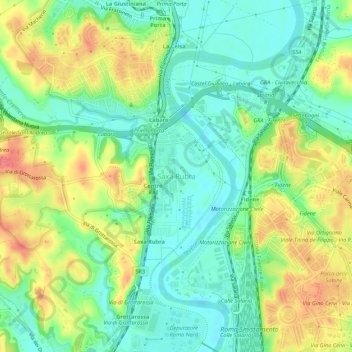
Name: Saxa Rubra topographic map, elevation, terrain.
Location: Saxa Rubra, Roma, Lazio, 00138, Italia (41.96089 12.47721 42.00089 12.51721)
Average elevation: 38 m
Minimum elevation: 10 m
Maximum elevation: 81 m
Thank you for supporting this site ❤️
Make a donation
Make a donation
Other topographic maps
Click on a map to view its topography, its elevation and its terrain.
Monumento Naturale di Galeria Antica
Italia > Lazio > Roma > Roma > Osteria Nuova > Santa Maria di Galeria
Average elevation: 121 m