
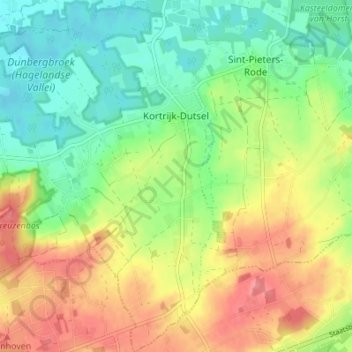
Kortrijk-Dutsel topographic map
Interactive map
Click on the map to display elevation.
About this map
Name: Kortrijk-Dutsel topographic map, elevation, terrain.
Average elevation: 43 m
Minimum elevation: 10 m
Maximum elevation: 85 m
Other topographic maps
Click on a map to view its topography, its elevation and its terrain.
Holsbeek
België > Vlaams-Brabant > Leuven > Holsbeek
Holsbeek, Leuven, Vlaams-Brabant, Vlaanderen, 3220, België
Average elevation: 31 m
Nieuwrode
België > Vlaams-Brabant > Leuven > Holsbeek
Nieuwrode, Holsbeek, Leuven, Vlaams-Brabant, 3221, België
Average elevation: 37 m
Sint-Pieters-Rode
België > Vlaams-Brabant > Leuven > Holsbeek
Sint-Pieters-Rode, Holsbeek, Leuven, Vlaams-Brabant, Vlaanderen, België
Average elevation: 41 m