
Aix-la-Chapelle topographic map
Interactive map
Click on the map to display elevation.
About this map
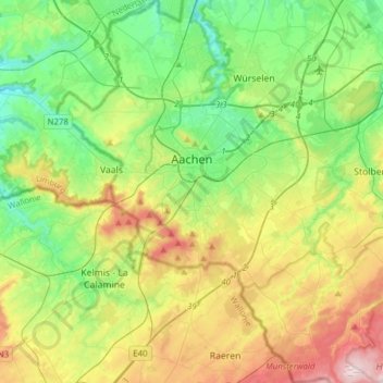
Name: Aix-la-Chapelle topographic map, elevation, terrain.
Average elevation: 225 m
Minimum elevation: 103 m
Maximum elevation: 456 m
Other topographic maps
Click on a map to view its topography, its elevation and its terrain.
Montjoie
Allemagne > Rhénanie-du-Nord-Westphalie > Région urbaine d'Aix-la-Chapelle
Montjoie, Région urbaine d'Aix-la-Chapelle, Rhénanie-du-Nord-Westphalie, 52156, Allemagne
Average elevation: 551 m
Loverich
Allemagne > Rhénanie-du-Nord-Westphalie > Région urbaine d'Aix-la-Chapelle > Baesweiler
Loverich, Puffendorf, Baesweiler, Région urbaine d'Aix-la-Chapelle, Rhénanie-du-Nord-Westphalie, Allemagne
Average elevation: 113 m
Dorff
Allemagne > Rhénanie-du-Nord-Westphalie > Région urbaine d'Aix-la-Chapelle > Stolberg
Dorff, Stolberg, Région urbaine d'Aix-la-Chapelle, Rhénanie-du-Nord-Westphalie, 52223, Allemagne
Average elevation: 254 m
Stolberg
Allemagne > Rhénanie-du-Nord-Westphalie > Région urbaine d'Aix-la-Chapelle
Stolberg, Région urbaine d'Aix-la-Chapelle, Rhénanie-du-Nord-Westphalie, Allemagne
Average elevation: 266 m