
Lessay topographic map
Interactive map
Click on the map to display elevation.
About this map
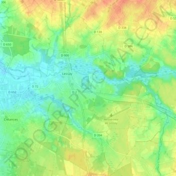
Name: Lessay topographic map, elevation, terrain.
Average elevation: 21 m
Minimum elevation: 2 m
Maximum elevation: 47 m
Other topographic maps
Click on a map to view its topography, its elevation and its terrain.
Les Landelles
France > Normandie > Manche > Lessay
Les Landelles, Lessay, Coutances, Manche, Normandie, France métropolitaine, 50430, France
Average elevation: 14 m
Sainte-Opportune
France > Normandie > Manche > Lessay
Sainte-Opportune, Lessay, Coutances, Manche, Normandie, France métropolitaine, 50430, France
Average elevation: 19 m
Notre-Dame
France > Normandie > Manche > Lessay
Notre-Dame, Lessay, Coutances, Manche, Normandie, France métropolitaine, 50430, France
Average elevation: 18 m