
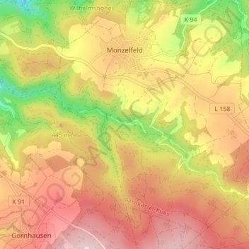
Monzelfeld topographic map
Interactive map
Click on the map to display elevation.
About this map
Name: Monzelfeld topographic map, elevation, terrain.
Average elevation: 424 m
Minimum elevation: 184 m
Maximum elevation: 606 m
Monzelfeld liegt auf der südlichen Anhöhe des Hunsrücks, etwa zwei Kilometer vom Moseltal bei Bernkastel-Kues entfernt. Der Weiler Annenberg befindet sich im Hinterbachtal.