
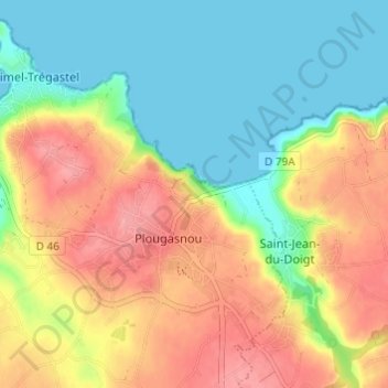
Kermaria topographic map
Interactive map
Click on the map to display elevation.
About this map
Name: Kermaria topographic map, elevation, terrain.
Average elevation: 41 m
Minimum elevation: -1 m
Maximum elevation: 90 m
Other topographic maps
Click on a map to view its topography, its elevation and its terrain.
Étang de Mesquéau
France > Bretagne > Finistère > Plougasnou
Étang de Mesquéau, Plougasnou, Morlaix, Finistère, Bretagne, France métropolitaine, 29630, France
Average elevation: 75 m
Corran
France > Bretagne > Finistère > Plougasnou
Corran, Plougasnou, Morlaix, Finistère, Bretagne, France métropolitaine, 29630, France
Average elevation: 43 m
Feunteunigou
France > Bretagne > Finistère > Plougasnou
Feunteunigou, Plougasnou, Morlaix, Finistère, Bretagne, France métropolitaine, 29630, France
Average elevation: 44 m