
Oakland County topographic map
Interactive map
Click on the map to display elevation.
About this map
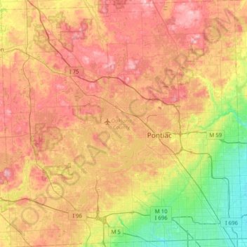
Name: Oakland County topographic map, elevation, terrain.
Location: Oakland County, Michigan, Vereinigte Staaten von Amerika (42.43118 -83.68944 42.88865 -83.08338)
Average elevation: 282 m
Minimum elevation: 191 m
Maximum elevation: 382 m
Das Oakland County ist ein County im US-Bundesstaat Michigan. Der Sitz der Countyverwaltung (County Seat) befindet sich in Pontiac. Es ist Bestandteil von Metro Detroit, der Metropolregion um die Stadt Detroit, und ist eine der wohlhabendsten Regionen der USA. Es verfügt über ein Zentrum der Technologie-Industrie, die inoffiziell Automation Alley genannt wird. Anders als die benachbarten Countys, in denen ein höherer Anteil an Arbeitern anzutreffen ist, arbeiten die Bewohner des Oakland County überwiegend als Angestellte, vor allem im Dienstleistungssektor, im Management oder in Büros.
Other topographic maps
Click on a map to view its topography, its elevation and its terrain.
Pontiac
Vereinigte Staaten von Amerika > Michigan > Oakland County
Pontiac, Oakland County, Michigan, Vereinigte Staaten von Amerika
Average elevation: 290 m
Bloomfield Township
Vereinigte Staaten von Amerika > Michigan > Oakland County
Bloomfield Township, Oakland County, Michigan, Vereinigte Staaten von Amerika
Average elevation: 272 m