Geolocate

Brian Head topographic map

Interactive map

Click on the map to display elevation.

About this map

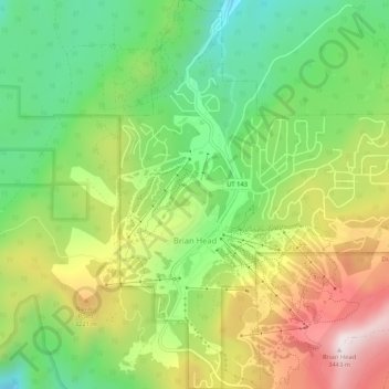
Name: Brian Head topographic map, elevation, terrain.

Location: Brian Head, Iron County, Utah, 84719, United States (37.67689 -112.86086 37.71835 -112.81505)

Average elevation: 3,031 m

Minimum elevation: 2,729 m

Maximum elevation: 3,449 m

The community, at an elevation of 9,800 feet (3,000 m) above sea level, is the highest town in Utah. It is located on State Route 143 and is east of Interstate 15. Brian Head is approximately three miles north of Cedar Breaks National Monument.

Wikipedia (CC-BY-SA 3.0)

Other topographic maps

Click on a map to view its topography, its elevation and its terrain.

Cedar City

United States > Utah > Iron County

Cedar City, Iron County, Utah, United States

Average elevation: 1,975 m

The Three Peaks

United States > Utah > Iron County

The Three Peaks, Iron County, Utah, United States

Average elevation: 1,789 m

Cedar Breaks

United States > Utah > Iron County

Cedar Breaks, Iron County, Utah, United States

Average elevation: 2,843 m

Newcastle

United States > Utah > Iron County

Newcastle, Iron County, Utah, United States

Average elevation: 1,640 m

Cedar City

United States > Utah > Iron County > Cedar City > Cedar City

Cedar City, Iron County, Utah, 84720, United States

Average elevation: 2,087 m

Beryl

United States > Utah > Iron County

Beryl, Iron County, Utah, United States

Average elevation: 1,573 m

Enoch

United States > Utah > Iron County

Enoch, Iron County, Utah, United States

Average elevation: 1,769 m

Strawberry Point

United States > Utah > Iron County

Strawberry Point, Iron County, Utah, 84772, United States

Average elevation: 2,436 m

Kanarraville

United States > Utah > Iron County

Kanarraville, Iron County, Utah, 84742, United States

Average elevation: 1,721 m

Parowan

United States > Utah > Iron County

Parowan, Iron County, Utah, 84761, United States

Average elevation: 2,002 m