
Thank you for supporting this site ❤️
Make a donation
Make a donation
Feldberg topographic map
Click on the map to display elevation.
Thank you for supporting this site ❤️
Make a donation
Make a donation
Feldberg
Feldberg is a municipality in the district of Breisgau-Hochschwarzwald in Baden-Württemberg in southern Germany. It is located near the Feldberg, the highest summit in Baden-Württemberg. It comprises the settlements of Altglashütten, Neuglashütten, Falkau, Bärental, and Feldberg. At an elevation of 1,277 m, the last is considered the highest village in Germany.
Thank you for supporting this site ❤️
Make a donation
Make a donation
About this map
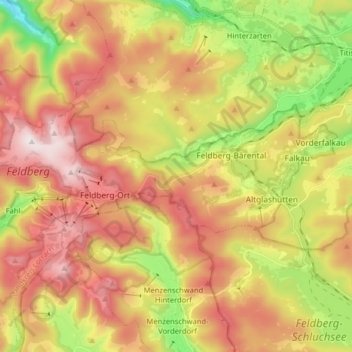
Name: Feldberg topographic map, elevation, terrain.
Average elevation: 1,037 m
Minimum elevation: 709 m
Maximum elevation: 1,448 m
Thank you for supporting this site ❤️
Make a donation
Make a donation