
Make a donation
Kilimanjaro topographic map
Click on the map to display elevation.
Make a donation
Kilimanjaro
Mount Kilimanjaro (/ˌkɪlɪmənˈdʒɑːroʊ/) is a dormant volcano in Tanzania. It is the highest mountain in Africa and the highest free-standing mountain above sea level in the world: 5,895 m (19,341 ft) above sea level and 4,900 m (16,100 ft) above its plateau base. It is also the highest volcano in the Eastern Hemisphere and the fourth most topographically prominent peak on Earth.
Make a donation
About this map
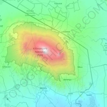
Name: Kilimanjaro topographic map, elevation, terrain.
Location: Kilimanjaro, Northern Zone, Tanzania (-3.39990 37.01058 -2.77881 37.80852)
Average elevation: 1,537 m
Minimum elevation: 705 m
Maximum elevation: 5,856 m
Make a donation
Other topographic maps
Click on a map to view its topography, its elevation and its terrain.
Make a donation
Moshi
Moshi's lower altitude and drier climate mean that the main crops grown on the higher slopes of Mt Kilimanjaro, coffee and bananas, do not thrive there. The surrounding areas in Moshi district are known for extensive farms of maize and beans, grown once per year during the long rainy season (known as "masika"…
Average elevation: 1,109 m
Make a donation
Moshi
Moshi's lower altitude and dry climate mean that the main crops grown on the higher slopes of Mount Kilimanjaro, coffee and bananas, do not thrive there. The surrounding areas in Moshi district are known for extensive farms of maize and beans, grown once per year during the long rainy season (known as "masika"…
Average elevation: 1,109 m
Make a donation
Make a donation
Make a donation
Same
The city is located in the interior of the island, 49 kilometres (30 mi) south of the provincial capital of Dili, at an altitude of 384 metres (1,260 ft), south of the mountain Cabalaki (Foho Kabulaki). The centre is located in the Suco Letefoho in which are situated the districts Ria-Lau (Rialau) Manico 1, 2…
Average elevation: 990 m
Moshi
Moshi's lower altitude and drier climate mean that the main crops grown on the higher slopes of Mt Kilimanjaro, coffee and bananas, do not thrive there. The surrounding areas in Moshi district are known for extensive farms of maize and beans, grown once per year during the long rainy season (known as "masika"…
Average elevation: 1,109 m
Make a donation
Make a donation