Geolocate

Old Toronto topographic map

Interactive map

Click on the map to display elevation.

About this map

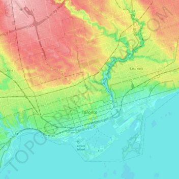
Name: Old Toronto topographic map, elevation, terrain.

Location: Old Toronto, Toronto, Golden Horseshoe, Ontario, Canada (43.61038 -79.49282 43.73602 -79.27851)

Average elevation: 116 m

Minimum elevation: 68 m

Maximum elevation: 201 m

Other topographic maps

Click on a map to view its topography, its elevation and its terrain.

Brampton

Canada > Ontario > Peel Region

Average elevation: 223 m

Kapuskasing

Canada > Ontario > Cochrane District

Kapuskasing lies in the heart of the Great Clay Belt. The topography of the region is very flat, dotted with numerous small lakes and muskeg bogs. Also in the heart of Canada's boreal forest, the region is drained by rivers running north to James Bay. The district is heavily forested, mostly by thick stands of…

Average elevation: 227 m

Hamilton

Canada > Ontario

Hamilton's climate is humid-continental, characterized by changeable weather patterns. In the Köppen classification, Hamilton it is on the Dfb/Dfa boundary, found in southern Ontario because the average temperature in July is 22.0 °C (71.6 °F). However, its climate is moderate compared with most of Canada.…

Average elevation: 187 m

Zorra

Canada > Ontario > Oxford County

Average elevation: 318 m

Scarborough Bluffs

Canada > Ontario > Toronto

Average elevation: 120 m

Markham

Canada > Ontario > York Region > Markham

Markham's average altitude is at 200 m (660 ft) and in general consists of gently rolling hills. The city is intersected by two rivers; the Don River and Rouge River, as well as their tributaries. To the north is the Oak Ridges Moraine, which further elevates the elevation towards the north.

Average elevation: 216 m

Toronto

Canada > Ontario > Toronto

Despite its deep ravines, Toronto is not remarkably hilly, but its elevation does increase steadily away from the lake. Elevation differences range from 76.5 metres (251 ft) above sea level at the Lake Ontario shore to 209 m (686 ft) above sea level near the York University grounds in the city's north end at…

Average elevation: 140 m

Kashechewan

Canada > Ontario > Kashechewan

Average elevation: 6 m

Georgetown

Canada > Ontario > Georgetown

Average elevation: 255 m

North Grenville

Canada > Ontario > North Grenville

Average elevation: 98 m

Joseph Island

Canada > Ontario > Muskoka Lakes

Average elevation: 236 m

Grand River

Canada > Ontario

Average elevation: 300 m

Oakville

Canada > Ontario > Oakville

Average elevation: 104 m

Cavan-Monaghan

Canada > Ontario > Cavan-Monaghan

Average elevation: 260 m

Georgian Bay

Canada > Ontario > Carling

Average elevation: 174 m

Ottawa

Canada > Ontario > Ottawa > Ottawa

Average elevation: 94 m

Kingcome Island

Canada > Ontario

Average elevation: 193 m

Kitchener

Canada > Ontario > Kitchener

Kitchener is in Southwestern Ontario, in the Saint Lawrence Lowlands. This geological and climatic region has wet-climate soils and deciduous forests. Located in the Grand River Valley, the area is generally above 300m (1000') in elevation.

Average elevation: 336 m

Peterborough County

Canada > Ontario

Average elevation: 260 m

Rainy Lake

Canada > Ontario > Unorganized Rainy River

Average elevation: 356 m

Leeds and Grenville Counties

Canada > Ontario

Average elevation: 116 m