
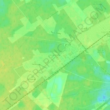
Les Arrestieux topographic map
Interactive map
Click on the map to display elevation.
About this map
Name: Les Arrestieux topographic map, elevation, terrain.
Average elevation: 52 m
Minimum elevation: 41 m
Maximum elevation: 57 m
Other topographic maps
Click on a map to view its topography, its elevation and its terrain.
Sardine
France > Nouvelle-Aquitaine > Gironde > Pessac
Sardine, Pessac, Bordeaux, Gironde, Nouvelle-Aquitaine, France métropolitaine, 33600, France
Average elevation: 37 m
Doucet
France > Nouvelle-Aquitaine > Gironde > Pessac
Doucet, Chiquet-Fontaudin, Pessac, Bordeaux, Gironde, Nouvelle-Aquitaine, France métropolitaine, 33600, France
Average elevation: 31 m
Ladonne
France > Nouvelle-Aquitaine > Gironde > Pessac
Ladonne, Arago-La Chataigneraie, Pessac, Bordeaux, Gironde, Nouvelle-Aquitaine, France métropolitaine, 33600, France
Average elevation: 41 m
Magonty
France > Nouvelle-Aquitaine > Gironde > Pessac
Magonty, Pessac, Bordeaux, Gironde, Nouvelle-Aquitaine, France métropolitaine, 33600, France
Average elevation: 51 m
Chappement
France > Nouvelle-Aquitaine > Gironde > Pessac
Chappement, Cap de Bos, Pessac, Bordeaux, Gironde, Nouvelle-Aquitaine, France métropolitaine, 33600, France
Average elevation: 52 m