
Thank you for supporting this site ❤️
Make a donation
Make a donation
Les Tris topographic map
Click on the map to display elevation.
Thank you for supporting this site ❤️
Make a donation
Make a donation
About this map
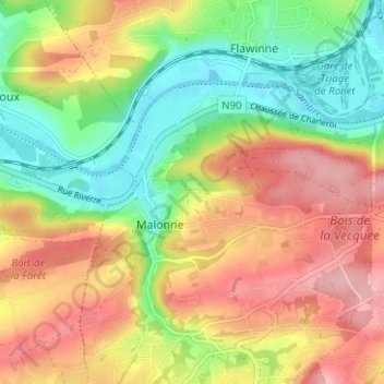
Name: Les Tris topographic map, elevation, terrain.
Location: Les Tris, Malonne, Namur, Wallonie, 5001, Belgique (50.42158 4.78193 50.46158 4.82193)
Average elevation: 148 m
Minimum elevation: 78 m
Maximum elevation: 221 m
Thank you for supporting this site ❤️
Make a donation
Make a donation