
Stölln topographic map
Interactive map
Click on the map to display elevation.
About this map
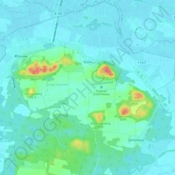
Name: Stölln topographic map, elevation, terrain.
Average elevation: 35 m
Minimum elevation: 24 m
Maximum elevation: 99 m
Other topographic maps
Click on a map to view its topography, its elevation and its terrain.
Großderschau
Deutschland > Brandenburg > Havelland > Rhinow
Großderschau, Rhinow, Havelland, Brandenburg, Deutschland
Average elevation: 27 m
Seeblick
Deutschland > Brandenburg > Havelland > Rhinow
Seeblick, Rhinow, Havelland, Brandenburg, Deutschland
Average elevation: 33 m
Gollenberg
Deutschland > Brandenburg > Havelland > Rhinow
Gollenberg, Rhinow, Havelland, Brandenburg, Deutschland
Average elevation: 34 m
Gülpe
Deutschland > Brandenburg > Havelland > Rhinow
Gülpe, Havelaue, Rhinow, Havelland, Brandenburg, Deutschland
Average elevation: 26 m