
Thank you for supporting this site ❤️
Make a donation
Make a donation
Houthem topographic map
Click on the map to display elevation.
Thank you for supporting this site ❤️
Make a donation
Make a donation
About this map
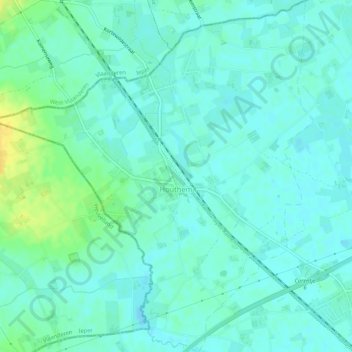
Name: Houthem topographic map, elevation, terrain.
Average elevation: 22 m
Minimum elevation: 16 m
Maximum elevation: 39 m
Thank you for supporting this site ❤️
Make a donation
Make a donation
Other topographic maps
Click on a map to view its topography, its elevation and its terrain.
La Lys
Belgique > Hainaut > Tournai-Mouscron > Comines-Warneton > Bas-Warneton
Average elevation: 18 m
La Lys
Belgique > Hainaut > Tournai-Mouscron > Comines-Warneton > Bas-Warneton
Average elevation: 18 m