
Thank you for supporting this site ❤️
Make a donation
Make a donation
Tilff topographic map
Click on the map to display elevation.
Thank you for supporting this site ❤️
Make a donation
Make a donation
Tilff
De rivier Ourthe loopt door het dorp van zuid naar noord. Aan de zuidzijde van Tilff liggen de Grotten van Sainte-Anne. De hoogte aan de Sint-Leodegariuskerk bedraagt 77 meter. De rotswanden herbergen nog diverse andere grotten.
Thank you for supporting this site ❤️
Make a donation
Make a donation
About this map
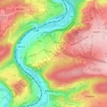
Name: Tilff topographic map, elevation, terrain.
Location: Tilff, Esneux, Luik, Wallonië, 4130, België (50.54200 5.56699 50.58106 5.61668)
Average elevation: 171 m
Minimum elevation: 63 m
Maximum elevation: 274 m
Thank you for supporting this site ❤️
Make a donation
Make a donation
Other topographic maps
Click on a map to view its topography, its elevation and its terrain.
Thank you for supporting this site ❤️
Make a donation
Make a donation