
Thank you for supporting this site ❤️
Make a donation
Make a donation
Victoria Peak topographic map
Click on the map to display elevation.
Thank you for supporting this site ❤️
Make a donation
Make a donation
Victoria Peak
Victoria Peak is a hill on the western half of Hong Kong Island. It is also known as Mount Austin, and locally as The Peak only generally. With an elevation of 552 metres (1,811 ft), it is the tallest hill on Hong Kong Island, and the 29th tallest in the territory of Hong Kong. It is a major tourist attraction offering views of Central, Victoria Harbour, Lamma Island and the surrounding islands.
Thank you for supporting this site ❤️
Make a donation
Make a donation
About this map
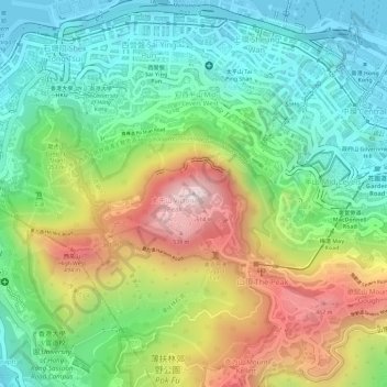
Name: Victoria Peak topographic map, elevation, terrain.
Location: Victoria Peak, Hong Kong, China (22.27599 114.14541 22.27609 114.14551)
Average elevation: 209 m
Minimum elevation: -2 m
Maximum elevation: 534 m
Thank you for supporting this site ❤️
Make a donation
Make a donation
Other topographic maps
Click on a map to view its topography, its elevation and its terrain.
Thank you for supporting this site ❤️
Make a donation
Make a donation
Thank you for supporting this site ❤️
Make a donation
Make a donation
Thank you for supporting this site ❤️
Make a donation
Make a donation
Thank you for supporting this site ❤️
Make a donation
Make a donation
Thank you for supporting this site ❤️
Make a donation
Make a donation