
Thank you for supporting this site ❤️
Make a donation
Make a donation
Cabin John topographic map
Click on the map to display elevation.
Thank you for supporting this site ❤️
Make a donation
Make a donation
Cabin John
Historically, Cabin John has been part of the region known as the Potomac Gorge (Potomac Palisades), an approximately 15-mile-long (24 km) corridor or "fall zone" that sees a transition between the hard bedrock of the Piedmont to the softer rocks and soils of the Atlantic Coastal Plain and representing a drop in elevation from 140 feet (43 m) to about 10 feet (3.0 m) above sea level.
Thank you for supporting this site ❤️
Make a donation
Make a donation
About this map
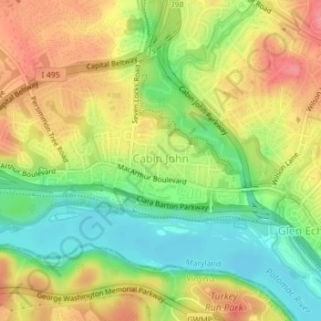
Name: Cabin John topographic map, elevation, terrain.
Average elevation: 48 m
Minimum elevation: 7 m
Maximum elevation: 90 m
Thank you for supporting this site ❤️
Make a donation
Make a donation