
Thank you for supporting this site ❤️
Make a donation
Make a donation
Stoney Fork topographic map
Click on the map to display elevation.
Thank you for supporting this site ❤️
Make a donation
Make a donation
About this map
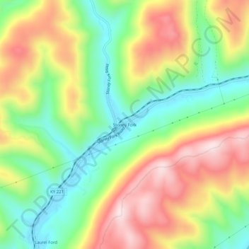
Name: Stoney Fork topographic map, elevation, terrain.
Location: Stoney Fork, Bell County, Kentucky, United States (36.81231 -83.55464 36.85231 -83.51464)
Average elevation: 519 m
Minimum elevation: 327 m
Maximum elevation: 755 m
Thank you for supporting this site ❤️
Make a donation
Make a donation
Other topographic maps
Click on a map to view its topography, its elevation and its terrain.
Pine Mountain State Resort Park
United States > Kentucky > Bell County > Pineville
Average elevation: 489 m