
Le Pont de la Barre topographic map
Interactive map
Click on the map to display elevation.
About this map
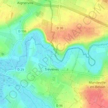
Name: Le Pont de la Barre topographic map, elevation, terrain.
Average elevation: 25 m
Minimum elevation: -1 m
Maximum elevation: 68 m
Other topographic maps
Click on a map to view its topography, its elevation and its terrain.
Le Beau Moulin
France > Normandie > Calvados > Trévières
Le Beau Moulin, Trévières, Bayeux, Calvados, Normandie, France métropolitaine, 14710, France
Average elevation: 13 m