
The Foothills topographic map
Interactive map
Click on the map to display elevation.
About this map
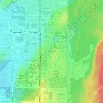
Name: The Foothills topographic map, elevation, terrain.
Location: The Foothills, Anchorage, Alaska, United States (61.20247 -149.73125 61.20704 -149.72243)
Average elevation: 89 m
Minimum elevation: 68 m
Maximum elevation: 128 m
Other topographic maps
Click on a map to view its topography, its elevation and its terrain.
Sunrise Terrace
United States > Alaska > Anchorage
Sunrise Terrace, Anchorage, Alaska, United States
Average elevation: 22 m
Botanical Gardens
United States > Alaska > Anchorage
Botanical Gardens, Anchorage, Alaska, United States
Average elevation: 28 m
Anchorage
United States > Alaska > Anchorage
Anchorage, Alaska, 99501, United States
Average elevation: 124 m