
Thank you for supporting this site ❤️
Make a donation
Make a donation
Greeley topographic map
Click on the map to display elevation.
Thank you for supporting this site ❤️
Make a donation
Make a donation
About this map
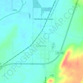
Name: Greeley topographic map, elevation, terrain.
Location: Greeley, Anderson County, Kansas, United States (38.36071 -95.13142 38.37540 -95.12129)
Average elevation: 279 m
Minimum elevation: 266 m
Maximum elevation: 323 m
Thank you for supporting this site ❤️
Make a donation
Make a donation
Other topographic maps
Click on a map to view its topography, its elevation and its terrain.