
Make a donation
Arendtsville topographic map
Click on the map to display elevation.
Make a donation
About this map
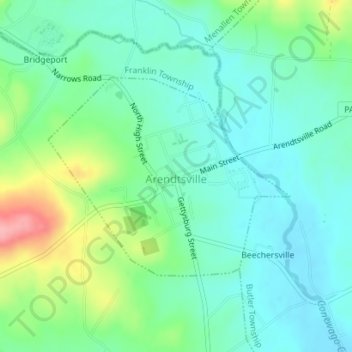
Name: Arendtsville topographic map, elevation, terrain.
Location: Arendtsville, Adams County, Pennsylvania, United States (39.91570 -77.31138 39.93091 -77.28712)
Average elevation: 219 m
Minimum elevation: 186 m
Maximum elevation: 305 m
Make a donation
Other topographic maps
Click on a map to view its topography, its elevation and its terrain.
Cemetery Ridge
United States > Pennsylvania > Adams County > Cumberland Township
Average elevation: 166 m
Make a donation
Make a donation
Iron Springs
United States > Pennsylvania > Adams County > Hamiltonban Township
Average elevation: 264 m
Maria Furnace
United States > Pennsylvania > Adams County > Hamiltonban Township
Average elevation: 291 m
Make a donation
Bermudian Creek
United States > Pennsylvania > Adams County > Latimore Township
Average elevation: 166 m
Make a donation
McKnightstown
United States > Pennsylvania > Adams County > Franklin Township
Average elevation: 193 m
Make a donation
Cress Ridge
United States > Pennsylvania > Adams County > Mount Pleasant Township
Average elevation: 177 m
Make a donation
Mount Hope
United States > Pennsylvania > Adams County > Hamiltonban Township
Average elevation: 395 m
Make a donation